VRX
What is VRX?
VRX is an advanced GNSS correction technology that provides accurate, real-time spatial positioning across Kuwait. By using this network, field teams experience true mobility because they can work entirely without the constraints of a physical base station or local radio signals. Instead, the network delivers high-level positioning accuracy directly to your rover via cellular connection.
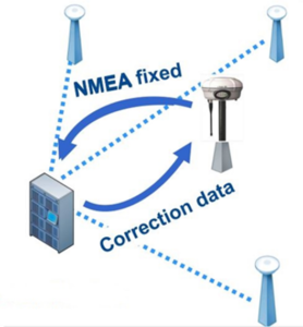
- Consequently, VRX introduces an innovative family of real-time GNSS positioning tools to Kuwait. Because it maximizes day-to-day surveying workflows, it gives your team the complete freedom to execute precise measurements anywhere in the field.
Why VRX Instead of Normal Surveying?
Traditional surveying requires field crews to manually set up a local base station for every single site visit. In contrast, VRX dynamically reduces the baseline distance between your rover and the network’s reference stations. Because it optimizes this baseline, it minimizes Parts Per Million (PPM) distance errors automatically.
- Furthermore, this setup ensures elite GNSS data accuracy regardless of how far your team travels from the nearest physical reference asset. Therefore, field crews save significant time and effort, which directly increases project productivity. In addition, field users no longer need to perform complex mathematical error modeling manually. The centralized network handles all advanced atmospheric and geometric error modeling before sending the coordinates to your controller.
Technical and Operational Benefits of VRX
Streamlined Field Equipment Setup
First, crews can easily work using only a single GNSS rover unit. Because you completely eliminate the physical base station and radio hardware, your operations gain massive flexibility. Eliminating these extra components saves crucial layout time on active construction corridors. Furthermore, field teams do not need to search for, verify, or physically set up equipment over pre-existing Control Points or Benchmarks. As a result, your business saves significant operational hours during the early phases of site mobilization.
Instant Digital Deliverables
Second, VRX removes the traditional need for extensive office post-processing or expensive standalone baseline processing software. Instead, field surveyors receive final, engineering-grade coordinates immediately on-site. The network exports data directly into standard file formats, including CAD files and CSV spreadsheets, to streamline your engineering design pipeline.
Practical Applications for Local Engineering Projects
Civil Infrastructure and Pipelines
During complex utility layouts and pipeline extensions, VRX consistently provides highly accurate vertical level data. Consequently, engineers can avoid using manual optical levels or robotic total stations for cross-country routes. This advanced network connectivity prevents common field alignment mistakes, such as cumulative reading errors or physical benchmark movement over time.
Unified Project Datums
Because our regional reference stations tie directly to each other, the network delivers a highly stable, uniform coordinate framework. Additionally, an unlimited number of rovers can connect to the system simultaneously. This means every subcontractor and field team on a massive civil asset connects to the exact same spatial network. Ultimately, using this shared datum reduces human error and eliminates discrepancies between different layout crews.
Advanced Proximity Modeling
To ensure maximum precision, the centralized system calculates your position and automatically generates a “Virtual Reference Station” exceptionally close to your active rover—typically less than 10 meters away. This localized proximity keeps the physical baseline short, which reduces PPM errors down to absolute negligible levels. Therefore, Vision International’s VRX network serves as a highly dependable reference system for topographic mapping, GIS data capture, and heavy structural layout surveying across Kuwait.
Vision Online GIS Platform MDA HUB
MDA HUB is an online GIS


